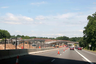
It had been six months (October 4; see Archive) since my last visit to the Metro construction site at Tyson's Corner. I've been procrastinating big time; I just couldn't bring myself to wade back into that traffic hell-hole. Finally, on June 13, I "screwed my courage to the sticking place" (Macbeth) and headed west from Rosslyn on I-66.
The Silver Line begins as an elevated turnout off the main line a short distance before the Beltway, curving north along VA route 267. When 267 reaches the Beltway it becomes the Dulles Toll Road, but just before that, the Silver Line turns southwest and follows VA route 123, aka Chain Bridge Road, towards Tyson's Corner. Let's take a look [CLICK PHOTOS TO ENLARGE]:
Here's where the elevated track turns north along VA route 267:
The Silver Line's route through this area is highlighted below in yellow. Notice what happens at Tyson's Corner. See the broken red line? That's the cut-and-cover tunnel along route 123. The tunnel begins just east of International Drive, exits at the intersection with route 7, then follows 7 northwest toward the Dulles Toll Road:
Below we're off I-66 onto route 7, letting the Silver Line proceed along 267 without me, and am now approaching Tyson's Hell:
These giant orange-and-blue things were not erected by Gator fans from the University of Florida. They appear to be precision-aimed supports that hold the forms into which concrete will be poured when building a support pier:
Note the detail in this form, tailor-made for all kinds of hardware and stuff to fit neatly in--or not:
Steel forms are being readied for a major serving of concrete:
A close-up look at the steel forms into which concrete will be poured to create the T-shaped pier:
Steel forms lying on the ground. Clamp 'em together like clamshells:
Now let's move to route 123, Chain Bridge Road. Climb the hill going west, turn around, and look back east. Notice the guideway entering the hill at the east portal of the cut-and-cover tunnel. Going away into the distance, the line curves to the left for a short run along 123 before moving over into the middle of route 267 on its way east back to the mainline switch in I-66:
For a better view of the east portal, I walked out onto the second-floor patio of the Courtyard by Marriott on route 123 and pointed the camera east. The Metro line is in the center, and off to the right is a new highway bridge across the Beltway:
And then I noticed this peculiarity to the right of the crane. What are those things that look like a pile of rusty pipes?
A tight zoom revealed (drum roll) this was the west portal. Those pipe-like things are steel beams holding the framework around the portal. Look closely and at the back wall you can even see the wooden planks covering the entrance:
Now we're on route 123 driving east toward route 267, the way back to I-66:
"Return of the Giant Killer Grasshoppers from Uranus!" No, it's a lifting gantry, used to move long sections of concrete guideways into place:
Now we're looking east toward the line's sweeping curve back toward 267 and eventually I-66:
And here we part company with the elevated track as it curves southeast toward 267 and back to I-66:
John


No comments:
Post a Comment