Seven years ago the developers of Potomac Yard proposed a "linear" park running along the eastern edge of old Pot Yard, abutting CSX's right-of-way. The park would be designed and built by contractors hired by the developers, then turned over to the City of Alexandria upon completion. And so they did. Design work and construction was handled by LPDA (Land Planning & Design Associates) of Charlottesville and Sterling, and on Saturday, December 14, Potomac Yard Park was officially dedicated. Alexandria's mayor, who was present at the dedication, called it "a gift to future generations."
The narrow, 24-acre park runs north and south between Potomac Avenue and the CSX tracks. At its north end Potomac Avenue intersects with E. Glebe Road; at the park's south end, E. Howell Avenue meets Potomac Avenue a short distance from the Slater's Lane signal bridge. Within the park are four "belvederes" or plazas offering views of the railroad. Midway there's a large children's playground. A number of historical signs throughout the park tell the history of Potomac Yard. One of the belvederes features a stylized (and greatly simplified) track layout, set in concrete, of the former rail yard, along with the names of the yard's five original tenant railroads--the first yard in the U.S. to be jointly owned by its several users. An agreement was signed in 1901, and the yard opened for business in 1906.
Alas, the slope behind the belvederes leading down to the tracks has been heavily landscaped with young trees--great for aesthetics, not so for train photographers. In many places tall shrubs and even trees within the CSX right of way obscure the railfan's view of oncoming trains. You need to visit Potomac Yard Park to find the best spots; there are some here and there--if you invest the time to find them.
My photo tour was shot Thursday, December 19, between 3:30 and 4:30 p.m. as the sun was nose-diving for the horizon--not an ideal time of day, but the only opportunity I've had recently. Please pardon the long shadows and intense orange light! The tour begins at the north end of the park and progresses southward to Slater's Lane . . .
---CLICK ON ANY PHOTOGRAPH TO ENLARGE IT---
 |
| The design firm's plan for the park. North is to the left. Quality of this drawing is low-resolution, unfortunately. |
 |
| And so I created my own map, albeit a bit crude. The park was drawn in with my mouse. The red blocks are belvederes (plazas). In the middle, marked "PG," is the playground. I've highlighted in yellow the streets intersecting with the belvederes. |
 |
| Here's the belvedere at the north end, where E. Glebe meets Potomac Avenue. Note the chain-link fence at the back of the picture. That's the park's northern boundary. I do not know what the construction is beyond the fence. |
 |
| What purpose is served by the overhead structure escapes me, other than "design for design's sake." |
 |
| Looking south down the RF&P . . . |
 |
| . . . and looking north. The freight train on track 1 (farthest from the camera) is Q409, and it has stopped. It's crew "went on the law" and bailed out, hitching a ride home on a passing Amtrak train (per Mike Schaller). |
 |
| Walking south along the paved trail through the park, we come to the next belvedere, at Swann Avenue. |
 |
| This odd-shaped platform memorializes the names of Pot Yard's five original railroads, which signed an agreement in 1901 for shared ownership and operation of the yard. |
 |
| Oops! the B&O RailWAY? |
 |
| Northward view. |
 |
| Southward view. Note the photographically-annoying shrubs and trees inserted by the design firm. And they're only going to grow larger . . . |
 |
| I was puzzled to discover steps in several places leading down to a gravel path that runs along CSX's chain-link fence--puzzled, because there's a new paved path up at the level of the belvederes and Potomac Avenue. With a small stepladder, however, a railfan could easily peek across the fence to improve his shot. |
 |
| The playground, and boy, was it humming (and shrieking) this particular afternoon! |
 |
| This belvedere is across from E. Custis Avenue. |
 |
| Looking north (love those trees) . . . |
 |
| . . . and south. |
 |
| This structure is not exactly a belvedere but a stage. I guess the designers heard banjo music in their heads and couldn't resist . . . |
 |
| Facing southward . . . |
 |
| . . . and northward. More trees. |
 |
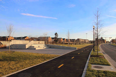
| Turning south along the trail we detect in the distance the pump house (large brick building) next to which the designers have installed tennis and basketball courts. |
 |
| There's a pretty decent view of southbound trains if you creep out onto the far edge of the concrete wall . . . very . . . carefully. |
 |
| Immediately south of the basketball courts is this last belvedere, opposite E. Howell Avenue. |
 |
| And it's an odd one. It looks like a miniature corral. In the middle, however, is what appears to be a small drainage pond. |
 |
| Looking north . . . |
 |
| . . . and south. Thanks, CSX, for those trees left to block the Slater's Lane signal bridge. |
 |
| Near the signal bridge is the US1 highway bridge. We are now at the south end of Potomac Yard Park, so we spin around and face north before departing . . . |
 |
| One last feature of the yard, near that last belvedere, is this "rock garden," for lack of a fancier term. Note in the distance one last historical sign. |
 |
| And that concludes the tour of Alexandria's brand-new Potomac Yard Park. We may grumble about the views, but they work just fine for this little railfan! |


No comments:
Post a Comment